Grade 4 History & Geography
Study Bibles 26
Chapter 1: Measuring Distance on a Map
Why do we need different kinds of maps?
Keep this question in mind as you read. You’ll answer it at the end.Words to know
- map
- a drawing or picture on a flat piece of paper of a specific place or area of Earth’s surface that shows different featuresThe visitors used a map to find their way in the foreign city.
- symbol
- an object or picture that stands for something elseMaggie used the map scale to determine how far it was from Tucson to Phoenix.
- kilometer
- a distance of one thousand meters, or 0.62 milesFrankie began his training program by running one kilometer without stopping.
- distance
- how far it is from one point to anotherLi found that the distance between her home and her school was five miles.
- direction
- where a person or object is facing or moving towardPeter asked the tour guide which direction he should take to get to the zoo.
- compass rose
- a symbol on a map that shows the directions for north, south, east, and westUsing the compass rose, Sonia figured out that Denver was west of Pittsburgh.
- interstate highway
- a major divided highway that runs through more than one stateThe fastest way to get from Carson City, Nevada, to Los Angeles, California, is to take the interstate highway.
Read: Chapter 1, “Measuring Distance on a Map”
Read it aloud together, or let your student read on their own. Pictures and maps are part of the lesson — talk about them too.
Text version (for read-aloud apps and screen readers)
Chapter 1
Measuring Distance
on a Map
How Far Is It? The place is Boston,
The Big Question
Massachusetts. It is about 10:00 p.m.
Why do we need
on the night of April 18, 1775. Paul
different kinds of
maps?
Revere steps into a boat and crosses
the Charles River. After a short boat
ride, Revere lands in Charlestown. There, he borrows
a horse. He’s on an important mission, and there is no
time to lose.
Revere knows he must get to Lexington and warn Samuel Adams
and John Hancock. These two American leaders are in danger. British
troops are marching to Lexington to arrest them. The American
colonies need Adams and Hancock to provide leadership. Paul Revere
must get to them first.
As he rides, Revere calls out, “The regulars are coming out!” He wants
to let people know that British troops—the “regulars”—are marching
out of Boston. The people in the area need to be ready to defend
themselves.
2
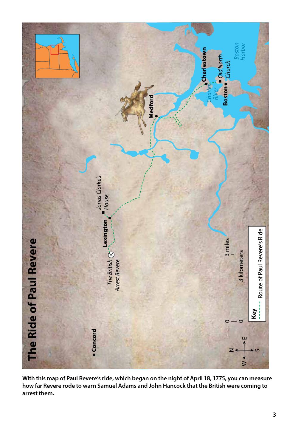
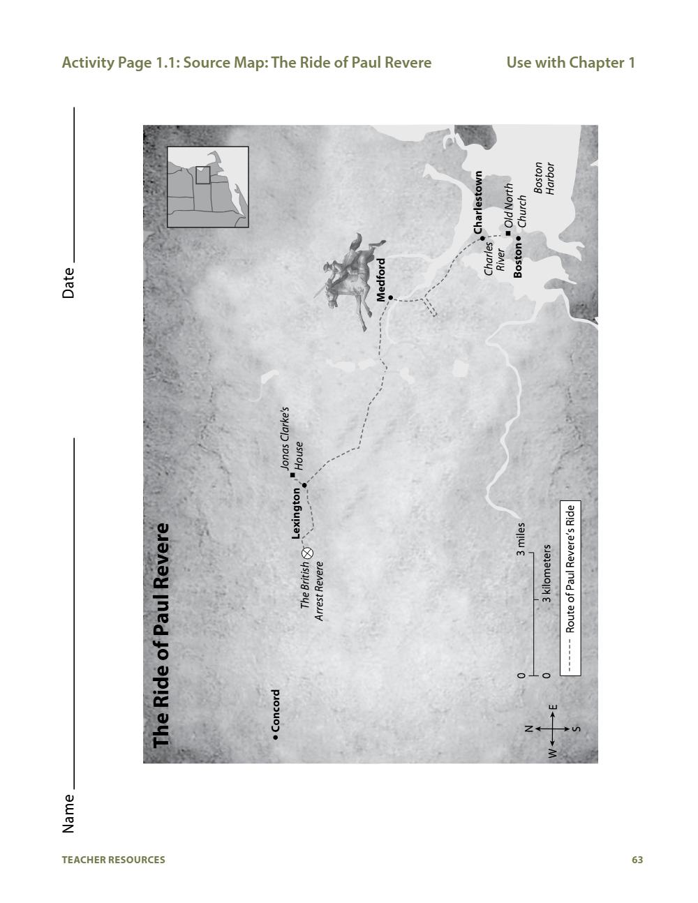
With this map of Paul Revere’s ride, which began on the night of April 18, 1775, you can measure
how far Revere rode to warn Samuel Adams and John Hancock that the British were coming to
arrest them.
3
W
S
N
E
Concord
0
0
Key
3 miles
Route of Paul Revere’s Ride
3 kilometers
The British
Arrest Revere
Lexington
The Ride of Paul Revere
Jonas Clarke's
House
Boston
Charles
River
Medford
Old North
Church
Boston
Harbor
Charlestown
About 11:30 p.m., Revere reaches the town of Medford. He rides on
until he gets to Jonas Clarke’s house near Lexington. Adams and
Hancock are there, and Revere warns them to flee.
Next, Revere heads toward the nearby town of Concord. Before
he gets there, a British patrol arrests him. But Revere has done his
duty. He has already warned Adams and Hancock. The men have
managed to get away.
Later, on the morning of April 19, 1775, colonial soldiers and British
troops would fight the Battles of Lexington and Concord. These
battles would mark the beginning of the American Revolution.
Today, you can trace Paul Revere’s route. All
you need is a good map and the directions.
As you know, a map is a drawing of a real
place. Symbols on the map represent
different features of the place. For example,
a symbol for a road on a map stands for a
real road.
Look at the map of Paul Revere’s Ride on
page 3. In the bottom corner, there’s a small
box. This is the map key. The map key
contains information to help you decode
and understand the symbols on the map. In
this case, the key tells you that a dotted line
stands for the path of Paul Revere’s ride.
4
Vocabulary
map, n. a drawing
or picture on a flat
piece of paper of a
specific place or area
of Earth’s surface
that shows different
features
symbol, n. an object
or picture that stands
for something else
“map key,” (phrase),
a table or chart that
tells you what the
parts of a map mean;
the key is usually
found in one of the
corners of the map
The map also contains a small image that
looks like a ruler. This image shows the
map scale. A map scale shows you how a
distance on the map compares to the actual
distance on the ground.
The map scale shows that one-and-a-half
inches on the map is equal to three miles
or to well over three kilometers on the
ground. How do you know this? Take a ruler
and place it under the map scale. Beginning
Vocabulary
“map scale,”
(phrase), a measuring
tool on a map that
shows how distances
on the map relate to
actual distances on
the ground
kilometer, n. a
distance of one
thousand meters,
or 0.62 miles
at the left side of the map scale, measure one-and-a-half inches.
There is a mark at this same place on the map scale. The mark is
labeled three miles. To the left is a mark labeled three kilometers.
You can use this information to figure out distances on a map.
For example, what if you wanted to follow Revere’s route from
Medford to Lexington? How far would you have to walk? First,
measure the distance with your ruler. The route measures about
three inches. The map scale tells you that one-and-a-half inches on
the map equals three miles in real distance. One-and-a-half times
two equals three. Therefore, three inches on the map equals six
miles in real life.
Now see if you can figure out about how far Paul Revere rode. He
began in Charlestown. First he rode to Medford and then to Jonas
Clarke’s house. Next he rode toward Concord. He was captured
along the way. How far did he ride in total?
5
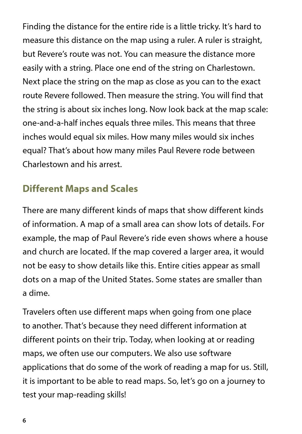
Finding the distance for the entire ride is a little tricky. It’s hard to
measure this distance on the map using a ruler. A ruler is straight,
but Revere’s route was not. You can measure the distance more
easily with a string. Place one end of the string on Charlestown.
Next place the string on the map as close as you can to the exact
route Revere followed. Then measure the string. You will find that
the string is about six inches long. Now look back at the map scale:
one-and-a-half inches equals three miles. This means that three
inches would equal six miles. How many miles would six inches
equal? That’s about how many miles Paul Revere rode between
Charlestown and his arrest.
Different Maps and Scales
There are many different kinds of maps that show different kinds
of information. A map of a small area can show lots of details. For
example, the map of Paul Revere’s ride even shows where a house
and church are located. If the map covered a larger area, it would
not be easy to show details like this. Entire cities appear as small
dots on a map of the United States. Some states are smaller than
a dime.
Travelers often use different maps when going from one place
to another. That’s because they need different information at
different points on their trip. Today, when looking at or reading
maps, we often use our computers. We also use software
applications that do some of the work of reading a map for us. Still,
it is important to be able to read maps. So, let’s go on a journey to
test your map-reading skills!
6
Suppose that you and your family live in Barstow, California. You
want to travel to San Diego to visit the zoo. You might use two maps
on your trip. First, you might use a map of Southern California to get
to San Diego. Once you reach the city, you might use a map of the
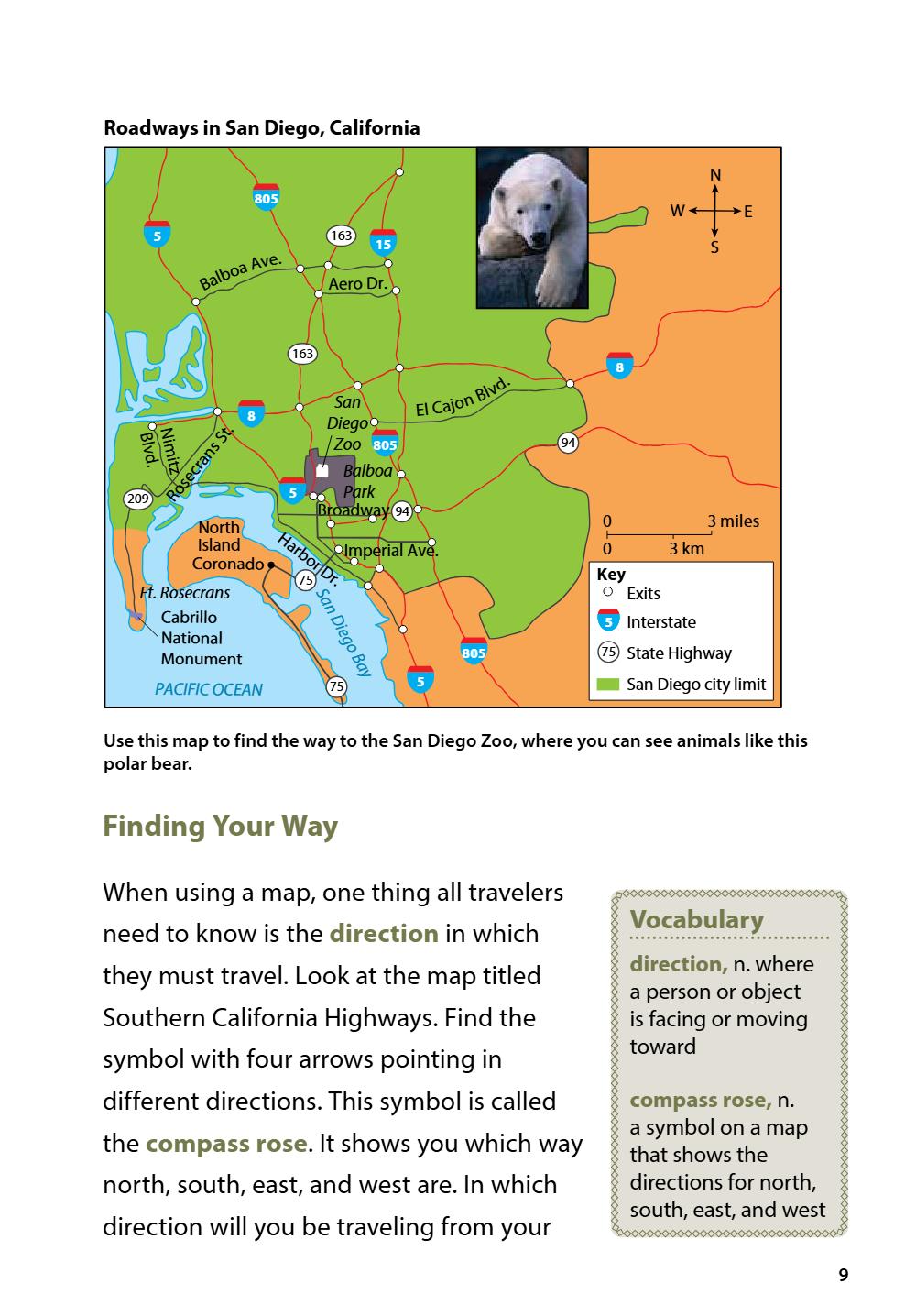
city to find the zoo. Look at the maps on pages 8 and 9. The map of
San Diego shows one small part of the map of Southern California.
It shows a lot of details, including many smaller streets. Can you find
the San Diego Zoo? Find the area marked Balboa (/bal*boe*uh/)
Park. The zoo is inside this large park.
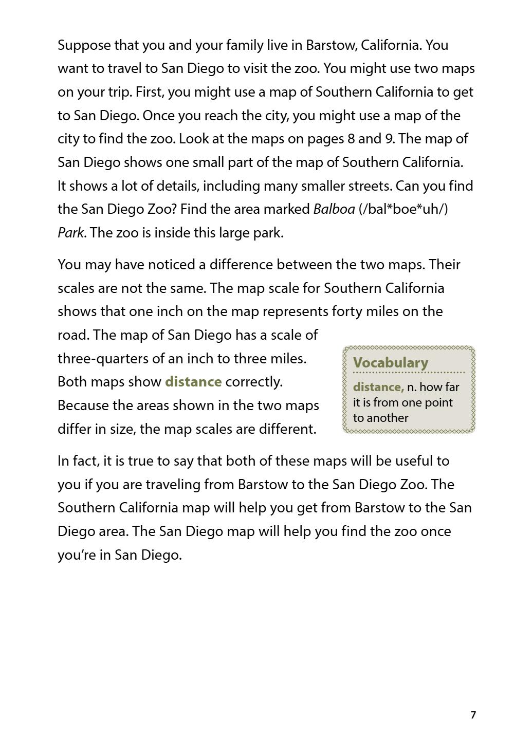
You may have noticed a difference between the two maps. Their
scales are not the same. The map scale for Southern California
shows that one inch on the map represents forty miles on the
road. The map of San Diego has a scale of
three-quarters of an inch to three miles.
Both maps show distance correctly.
Because the areas shown in the two maps
differ in size, the map scales are different.
Vocabulary
distance, n. how far
it is from one point
to another
In fact, it is true to say that both of these maps will be useful to
you if you are traveling from Barstow to the San Diego Zoo. The
Southern California map will help you get from Barstow to the San
Diego area. The San Diego map will help you find the zoo once
you’re in San Diego.
7
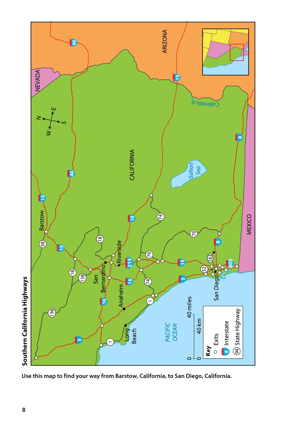
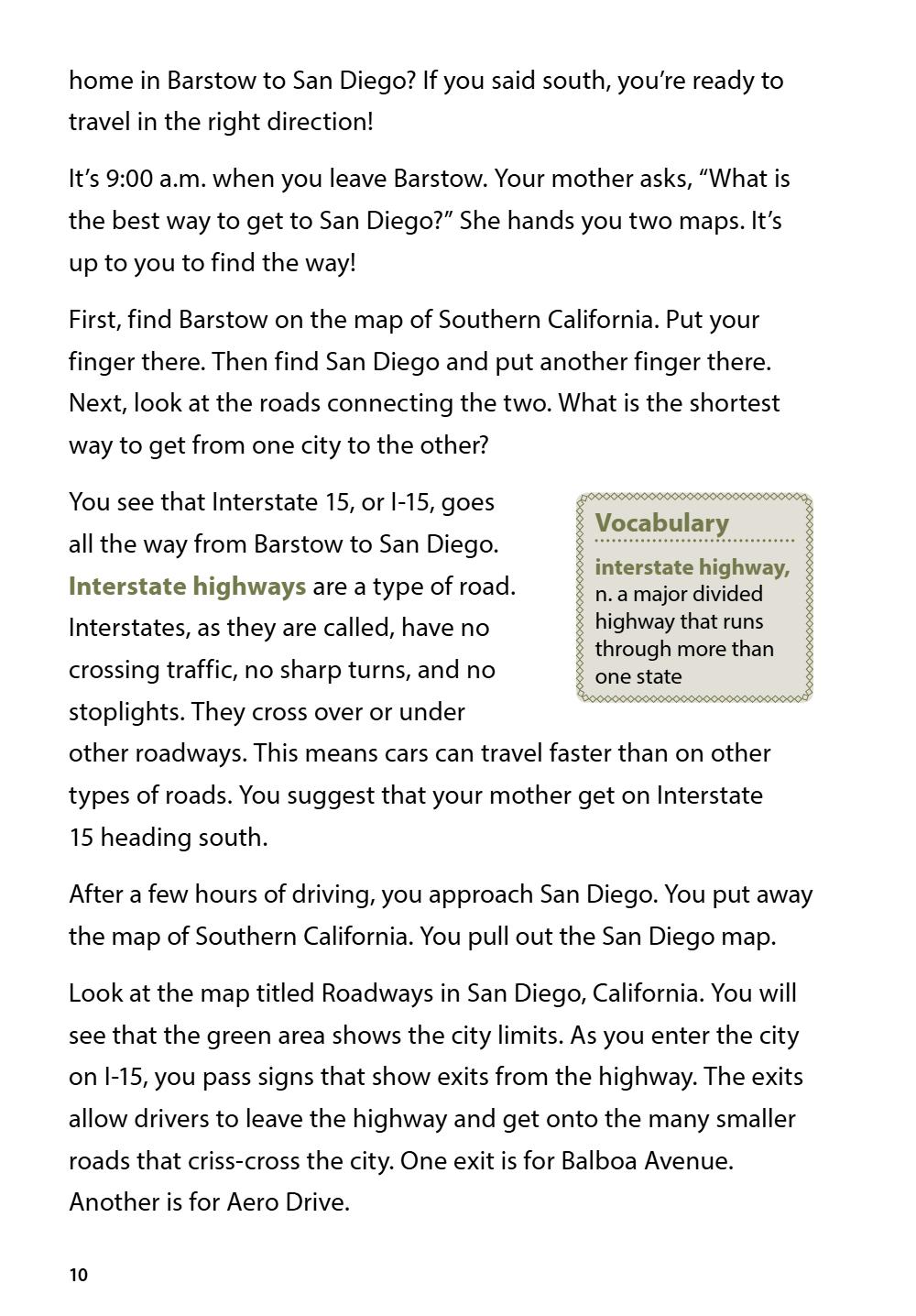
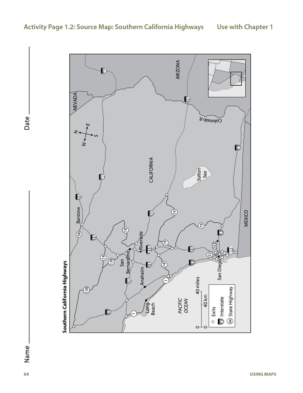
Use this map to find your way from Barstow, California, to San Diego, California.
0
0
Interstate
State Highway
94
Exits
1
138
18
18
San Diego
5
74
15
79
163
15
805
52
15
18
58
8
Riverside
215
San
Bernardino
Anaheim
10
40 miles
8
Key
40 km
PACIFIC
OCEAN
Long
Beach
11
5
138
Southern California Highways
MEXICO
79
74
10
Barstow
15
Salton
Sea
CALIFORNIA
40
8
W
S
N
E
Colorado R.
8
10
NEVADA
ARIZONA
4040
RoadwaysininSan
San
Diego,
California
Roadways
Diego,
California
N
805
805
W
163
5
5
Ave.
boaoa Ave.
l
a
B
16315
S
15
163
San
Diego
San
805
Zoo
Diego
tz
Ro Rose
se
c
cra ran
ns s St
St .
.
itizmi
NimN
d.
BlvdB. lv
209
5
El C aj o
nB
.
lvd
El C aj o
nB
8
.
lvd
94
Balboa
Zoo 805
Park
Balboa
Broadway
94
94
0
0
Key
San
75
5
805
3 miles
0 3 km
Exits0
3 miles
3 km
5
Key
Interstate
75
State Highway
Exits
5
Interstate
75
State Highway
San Diego city limit
ay
oB
Monument
yeg
BDai
gaon
DieS
National
PACIFIC
OCEAN
S
8
Park
5
North
Ha
Broadway
94
Island
rb
Imperial Ave.
o
Coronado
North
H75ar Dr.
Island
rb
Imperial Ave.
Ft. Rosecrans
or
Coronado
Dr
Cabrillo
75 .
Ft.National
Rosecrans
805
Monument
Cabrillo
209
E
Aero Dr.
163
8
WE
Aero Dr.
b
Bal
8
N
5
San Diego
city
limit
Use thisPACIFIC
map toOCEAN
find the way to75the San Diego Zoo, where you can see animals
like
this
polar bear.
Finding Your Way
When using a map, one thing all travelers
need to know is the direction in which
they must travel. Look at the map titled
Southern California Highways. Find the
symbol with four arrows pointing in
different directions. This symbol is called
the compass rose. It shows you which way
north, south, east, and west are. In which
direction will you be traveling from your
Vocabulary
direction, n. where
a person or object
is facing or moving
toward
compass rose, n.
a symbol on a map
that shows the
directions for north,
south, east, and west
9
home in Barstow to San Diego? If you said south, you’re ready to
travel in the right direction!
It’s 9:00 a.m. when you leave Barstow. Your mother asks, “What is
the best way to get to San Diego?” She hands you two maps. It’s
up to you to find the way!
First, find Barstow on the map of Southern California. Put your
finger there. Then find San Diego and put another finger there.
Next, look at the roads connecting the two. What is the shortest
way to get from one city to the other?
You see that Interstate 15, or I-15, goes
all the way from Barstow to San Diego.
Interstate highways are a type of road.
Interstates, as they are called, have no
crossing traffic, no sharp turns, and no
Vocabulary
interstate highway,
n. a major divided
highway that runs
through more than
one state
stoplights. They cross over or under
other roadways. This means cars can travel faster than on other
types of roads. You suggest that your mother get on Interstate
15 heading south.
After a few hours of driving, you approach San Diego. You put away
the map of Southern California. You pull out the San Diego map.
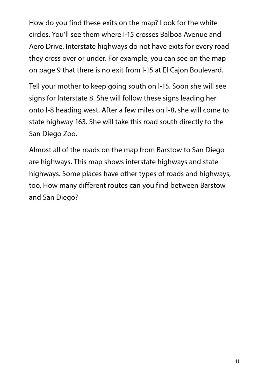
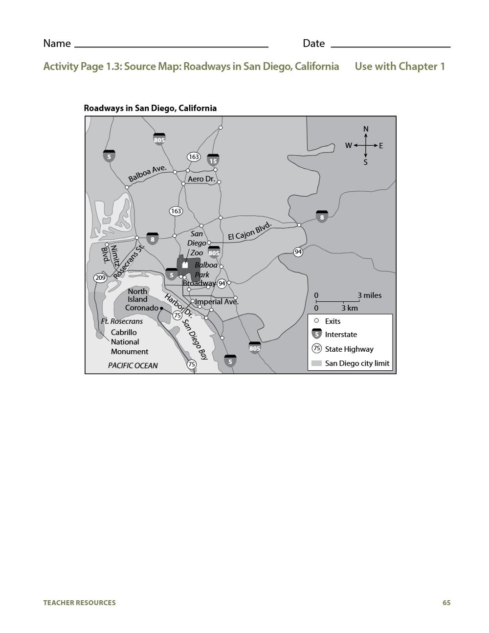
Look at the map titled Roadways in San Diego, California. You will
see that the green area shows the city limits. As you enter the city
on I-15, you pass signs that show exits from the highway. The exits
allow drivers to leave the highway and get onto the many smaller
roads that criss-cross the city. One exit is for Balboa Avenue.
Another is for Aero Drive.
10
How do you find these exits on the map? Look for the white
circles. You’ll see them where I-15 crosses Balboa Avenue and
Aero Drive. Interstate highways do not have exits for every road
they cross over or under. For example, you can see on the map
on page 9 that there is no exit from I-15 at El Cajon Boulevard.
Tell your mother to keep going south on I-15. Soon she will see
signs for Interstate 8. She will follow these signs leading her
onto I-8 heading west. After a few miles on I-8, she will come to
state highway 163. She will take this road south directly to the
San Diego Zoo.
Almost all of the roads on the map from Barstow to San Diego
are highways. This map shows interstate highways and state
highways. Some places have other types of roads and highways,
too, How many different routes can you find between Barstow
and San Diego?
11
Talk it over
Ask these as you read or afterward. Answers for the teacher are tucked under each question.
What information does a map key contain?
Answer
A map key contains information about the symbols used for items on the map such as towns, highways, schools, or mountains.
What can you tell by using the scale on a map?
Answer
You can tell the distance from place to place.
Why do mapmakers use map scales to represent distance?
Answer
The purpose of a map is to represent a very large area in a much smaller space. The map scale is a way to show how the actual area compares to what’s shown on the map.
Where is the San Diego Zoo located?
Answer
Students may respond that the San Diego Zoo is located in Balboa Park. It is also located in Southern California.
What information does the map of San Diego show?
Answer
The map of San Diego shows important roads and locations in the city of San Diego, for example, Balboa Park.
What information does the map of Southern California show?
Answer
The map of Southern California shows information about how to get between cities, including major highways.
Why might it be necessary for travelers to use both a city and a state or regional map to find their way?
Answer
Each type of map features different types of information. A regional or state map could be used to get the travelers to their destination city. Meanwhile, the city map can help them find important attractions.
What does a compass rose show?
Answer
A compass rose shows the directions north, south, east, and west.
According to the map of San Diego, which state highway travels in an east-west direction just south of Balboa Park?
Answer
State Highway 94 runs in an east-west direction just south of Balboa Park.
Why is it a good idea to know more than one route to your destination?
Answer
Possible answers: A road might be closed because of construction; you might decide on the way to visit something interesting, which would require you to use a different road.
Check for understanding
- Answer the Big Question out loud or in a sentence or two: Why do we need different kinds of maps?
What a good answer includes
Different kinds of maps show different kinds of information. For example, if you’re trying to get from one city to another, a map of each individual city may not be very helpful. Instead, you’ll need to use a map that shows information about the different routes you can take between the two cities.
- Pick one of today’s words and use it in a sentence of your own.
Activity pages
Print these from the Teacher Guide, or have your student answer on paper.
Activity Page 1.3: Source Map: Roadways in San Diego, California
For offline study
Download these once and you can teach this unit without the internet.
This course is based on an original work of the Core Knowledge® Foundation (www.coreknowledge.org) made available through licensing under a Creative Commons Attribution-NonCommercial-ShareAlike 4.0 International License. This does not in any way imply that the Core Knowledge Foundation endorses this work. PGAMO added the lesson pages, study packs and quizzes layout, and shares them under the same license. CC BY-NC-SA 4.0 · Core Knowledge History and Geography. Free for everyone — this course may never be sold.